DroneBase Recommended Drones + Which Missions Each Drone is Best For
As drone technology and the regulations surrounding its use continue to evolve, it’s a good idea to future-proof your gear and think about investing in specialized equipment.
DroneBase’s pool of customers and the type of Missions we commission are always expanding. That means more opportunities and increasingly lucrative work for our Pilot Network.
From mapping to thermal inspections, Missions that require higher-caliber drones, cameras, and expertise tend to yield a more substantial payout. So it pays to keep your gear up to date and remain at the forefront of drone technology.
Here are the best drones available in 2019 and some examples of how our Pilot Network can use them.
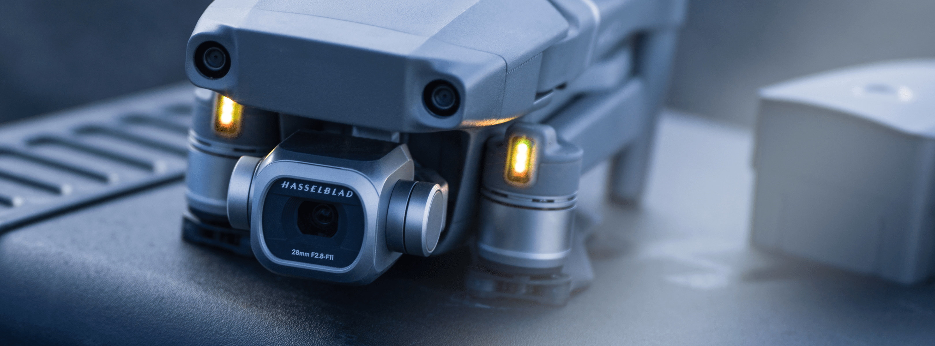
Our Go-To for Professional Aerial Photography: DJI Mavic 2 Pro
Choosing a drone for professional photography and video is tough. You’ve got to balance budget with capability and, in an ideal world, portability.
Taking those three factors into account, our preferred aerial photography drone is DJI’s foldable Mavic 2 Pro.
The Mavic 2 Pro is slightly bigger than the original Mavic, but there’s serious substance behind that extra size. It comes with a Hasselblad L1D-20c camera, which houses a 1” CMOS sensor, can snap 20MP stills and has an adjustable aperture from f/2.8-f/11.
The Mavic 2 Pro can record 3840×2160 10-bit 4K Dlog-M and 4K HDR 10-bit videos at 100 Mbps.
And, as you’d expect, the Mavic 2 Pro comes with all of DJI’s established autonomous flight modes and a few new ones, including a one-touch Hyperlapse.
When it comes to safety, the Mavic 2 Pro has also improved significantly from the original. DJI’s Advanced Pilot Assistance Systems now include omnidirectional sensors, keeping your Missions safe in complex environments and actively preventing crashes.
Flight time for the Mavic 2 Pro is a very respectable 31 minutes. DJI’s latest OcuSync transmission system offers 1080p live streaming and an operational range of up to five miles.
Mapping Missions
For Mapping Missions, we’d usually recommend a system such as the Phantom 4 Pro V2. It’s versatile, powerful and has a 20MP camera more than capable of capturing the detail required for accurate maps.
It’s also ideal for Mapping Missions because it has a mechanical shutter rather than a rolling one. So instead of recording frames line-by-line from top to bottom and generating a rolling shutter effect (when the subject of your photo is distorted because the camera or object moved before the full image was recorded), the mechanical shutter allows the sensor to record each line of the frame simultaneously.
This process makes it much easier for mapping software to match control points and build maps with greater accuracy.
If you can’t get your hands on a Phantom 4 Pro V2, which appears to have been discontinued by DJI, another great option for mapping is the newer Phantom 4 RTK, which has an integrated RTK module to provide real-time, centimeter-level positioning data, as well as a mechanical shutter.
Insurance Missions
Our Insurance Missions are focused on the practical process of gathering high-quality aerial images. Because of that, there’s a range of DJI drones that meet our criteria, whether you are carrying out a roof inspection or taking photos for an insurance claim.
The most important aspects your drone needs to cover are the ability to capture geo-referenced, 20MP images with accurate latitude/longitude and altitude recordings.
Essentially, any drone from DJI’s Phantom 4 Pro and onward is fair game.
The full list of acceptable drones for our Insurance Missions is below:
- DJI Phantom 4 Pro V2
- DJI Phantom 4 RTK
- DJI Phantom 4 Pro
- DJI Inspire 2 w/ 20 MP Camera
- DJI Mavic Pro 2 Pro
The same criteria apply for our Property Management Missions.
Thermal Inspection Missions
Thermal Missions are expected to play a big role in our future operations, which is why we’ve partnered with FLIR to enroll as many DroneBase pilots as possible for sUAS Level 1 Thermography Certification at one of the thermal specialist’s ITC centers.
In terms of hardware, the thermal options we’re recommending from DJI are the Zenmuse XT and XT2 640x512 13mm 9 or 30hz cameras, both of which include FLIR sensors. The Zenmuse XT can be flown with the Inspire 1 and the Zenmuse XT2 can be operated with the DJI M200, M210 and M600.
Want to learn more about being a professional drone pilot? Read about our available drone pilot jobs and get paid to fly missions!
If you want to find out more about taking your missions with DroneBase to the next level, have a read of our recent post on completing thermography certification with FLIR.