We recently launched a new feature to our Property Insights Platform that puts more power in the hands of our customers. Now, our users can create, edit and share details of a property inspection.
The DroneBase Property Insights Platform is used by real estate, construction, insurance and property management professionals who need detailed aerial data and actionable insights about the buildings they sell, manage or insure. Prior to this release, our Property Insights customers relied entirely on our excellent team of analysts to review and mark up property inspection data.
Customers now have the option to create and edit inspection details and anomalies across all inspections, new and existing. These new or edited details allow customers to use their own internal analysis teams to review and inspect data, change the severity and classification of anomalies and generate new reports.
Based on the user-added information, Property Insights will automatically provide a hazard statement and a recommendation for repair that can be edited.
How to create inspection details in DroneBase Property Insights
We wanted to give our users more control while ensuring the data is well managed. Any user who is a designated Admin, Site Manager or Engineer has the ability to create new annotations and edit existing ones.
Customers can still order a DroneBase condition report if they prefer our analysts to manage the reviews and markups. If not, eligible users can review and mark up the images as soon as they are available. (After a user adds an annotation to the mission, their name will be displayed in the Analyzed By column on the Missions index list.)
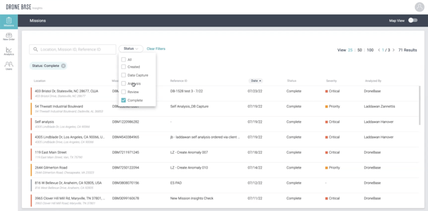
Selecting the “Analysis” status filter allows you to quickly see projects that are ready for analysis.
Selecting a blue dot on top of an orthomosaic map opens the image, and users can start marking it up: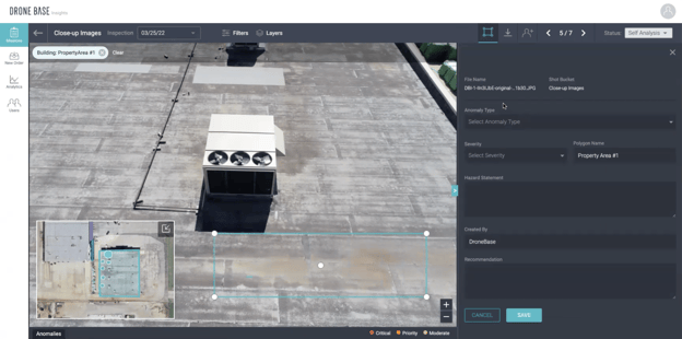
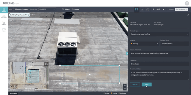
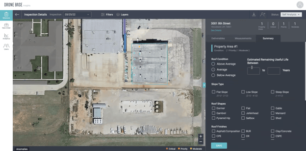
Property Insights will prompt users to provide details such as anomaly type and severity, and then automatically provide a hazard statement and a recommendation for repair that can be edited by the user.
Using this process, users can review the imagery and place anomalies across the property. Once complete, providing a summary in the right-hand panel adds important context to the final report, such as the roof condition, the roof’s ERUL, and roof shape and slope.
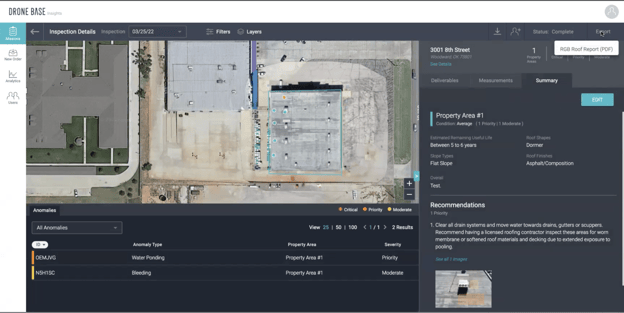
Once in the complete status, users can export a newly generated report, which will be emailed to the user requesting it.
Editing inspection details in DroneBase Property Insights
You can start editing an existing inspection as soon as its status has progressed to “review.” Users can edit inspection data from a list of predefined anomaly types. You can change the severity of issues and edit text fields including hazard statements and recommendations.
If DroneBase initially performed the analysis the “created by” field will say DroneBase, if the user did the analysis the user name will show in its place.
Want to see more? Schedule a demo.