About Texas Roadhouse
Texas Roadhouse is an American chain restaurant founded in 1993 and headquartered in Louisville, Kentucky, that specializes in serving American cuisine from steaks and ribs to sides & fresh-baked rolls. Texas Roadhouse operates one of the largest restaurant chains in the U.S, with over 600 locations in nearly 50 U.S. states.
Texas Roadhouse began using drone imagery in 2018 as a means to track renovation and construction site progress. However, 2020's COVID-19 outbreak required them to not only adapt the way they were monitoring sites under construction; it completely changed their day-to-day operations. With the establishment of local restrictions that limit face-to-face contact, there became a pressing need for a solution that could support standard operations without putting employees at risk.
"Recently, Texas Roadhouse decided to leverage the nationwide coverage of DroneBase to photograph our entire 650 location portfolio. We have been intimately aware of the speed, quality, and ease of workflow, having partnered with DroneBase over a couple of dozen projects in the past," said Parker Harrington, Regional Real Estate Director at Texas Roadhouse. "It was nonetheless refreshing and satisfying seeing the same quick turnaround and caliber of results with such a large project in 48 states and every corner of the United States."
The Differentiators
Following the enactment of COVID-19 protocols, traditional workflows were limited. Texas Roadhouse needed a way to safely visualize its locations to assess roofs, parking lots, landscaping conditions, and renovations related to pickup windows. DroneBase was the clear choice:
-
-
Nationwide Scale: Through a network of more than 80,000 licensed drone pilots, DroneBase captured more than 600 restaurant locations spread throughout the U.S in a fraction of the time it would typically take.
-
Expertise: DroneBase offers one streamlined solution ranging from flight scheduling and imagery capture to data processing and analysis. Rather than coordinating with multiple organizations, Texas Roadhouse can rely on one source for reliable aerial data.
-
Safety: DroneBase's contactless inspections improve team safety and reduce liability by mitigating the need to send someone up on the roof. At a time when face-to-face contact is limited, DroneBase’s pilots can complete safe and contactless flights, often without ever needing to step foot in or on the property.
-
Accuracy: Building blueprints and satellite imagery are often outdated or low resolution, and to precisely determine which locations require renovations, Texas Roadhouse required access to accurate and up-to-date imagery.
-
The Solutions
In addition to the nationwide scale and expertise, DroneBase’s advanced and consistently improving technology is another key differentiating factor, particularly the DroneBase client dashboard. Through one streamlined platform, the Texas Roadhouse team can view their full list of locations, monitor each mission’s status, view account analytics, place new orders, and share or download their deliverables.
-
-
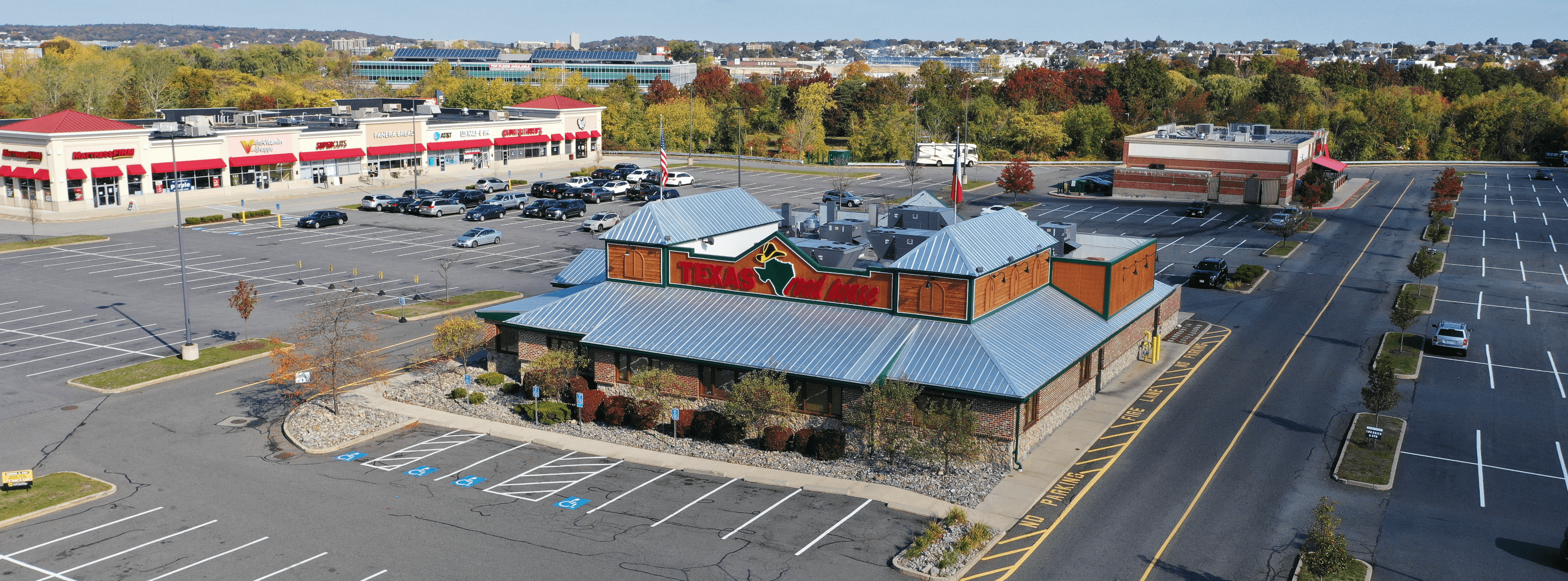
Panorama(s) - Texas Roadhouse uses panoramas to capture a full 360-degree interactive perspective of the entrances and exits to the restaurant. The ability to adjust angles and interact with the panorama helps their team better understand potential liabilities at the entry and exit points to each building.
-
Orthomosaic(s) - An orthomosaic is a stitched image composed of many individual still photos combined together. Texas Roadhouse is using orthomosaics to better-assess their roof, parking lot, and landscaping conditions. Additionally, the stitched orthomosaics are used to identify driveways and access points in and out of the property.
-
-
-
Birds-Eye Images - These images provide a top-down view of the property and are primarily used by Texas Roadhouse to identify rooftop assets such as HVAC units. These images can also be utilized within DroneBase's Insights Roof Reports to identify potential rooftop anomalies such as debris or overhanging vegetation that may lead to expensive repairs if left unaddressed.
-
Cardinal Direction Images - Cardinal Direction images help Texas Roadhouse build a property overview that showcases the property and its surroundings from multiple angles. These overviews are being used to streamline and improve collaboration between Texas Roadhouse and its vendors. Rather than arriving at a property the vendor is not familiar with, Texas Roadhouse can share imagery in advance. Upon arrival, the vendor already has a sense of the property and what should be prioritized.
-
Doing More with Aerial Data
Extending beyond the initial use case of capturing each location in response to COVID-19, Texas Roadhouse finds added value in maintaining an accessible repository of aerial imagery. "The aerials have been invaluable as we analyze our locations, schedule capital improvements, negotiate with landlords, track construction progress, outline renovations, and plan for the continued years of growth as we expand our brands," said Harrington.
In one instance, the Texas Roadhouse legal team used aerial imagery when completing the process of renewing their liquor licenses in the state of Massachusetts. As part of the renewal process, imagery of the building’s exterior must be reviewed to ensure the property meets all requirements. The Texas Roadhouse legal team was able to view all their Massachusetts locations and answer all questions, ultimately mitigating the need to send out teams to collect information manually.
Accurate and up-to-date imagery also enables Texas Roadhouse's organization to streamline construction and prioritize repairs for all of its locations. Rather than dispatching a team with minimal knowledge of a site, they are able to share imagery with repair teams before arrival, enabling them to better navigate the site and quickly address each item based on priority.
Why DroneBase?
Trusted by enterprises across a multitude of industries, DroneBase is reshaping the ways businesses collect, manage, and store their aerial data within each phase of an asset’s life cycle. Our robust technology and user-friendly platform, coupled with our expertise and nationwide scale, provides an end-to-end solution that balances efficiency and speed with innovation and safety.
For more information on how DroneBase can improve your existing workflows with aerial data, visit our industries page.